Safer Streets Priority Finder
National
Project Summary
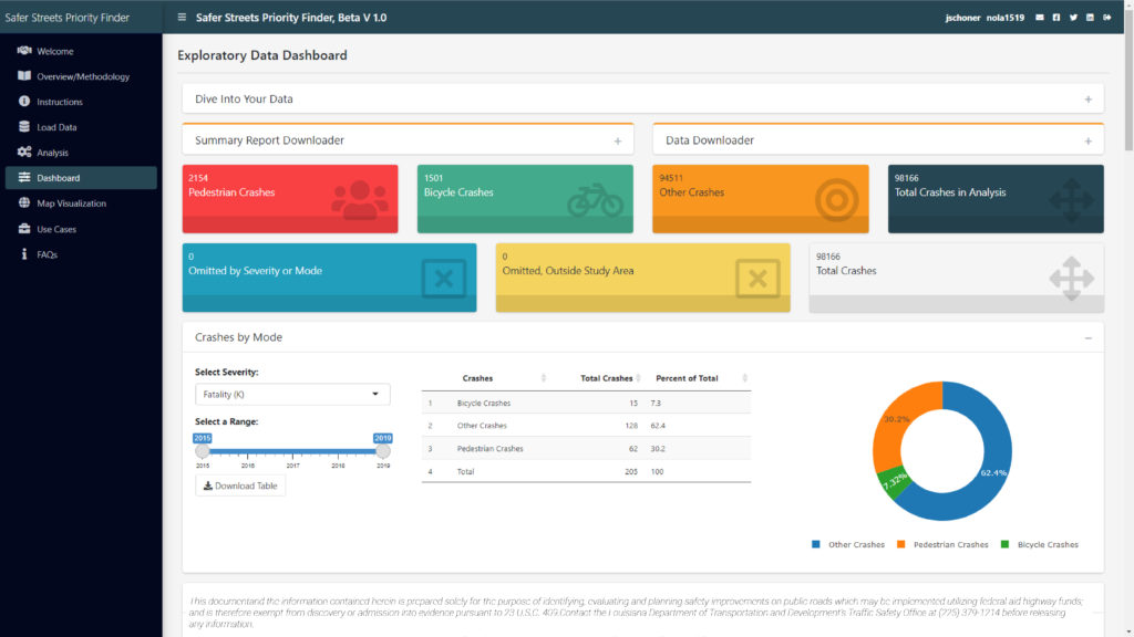
Most municipalities and jurisdictions face an overwhelming array of safety issues with limited funding to address them. State and local agencies need to be able to identify areas of greatest need and use their tight budgets in a way that will have the largest impact on safety outcomes. In response, Toole Design developed the Safer Streets Priority Finder (SSPF) to assist state and local agencies to improve safety, access, comfort, and mobility for all street users.
The SSPF takes into consideration areas where a disproportionate share of fatal and serious injury crashes have occurred and identifies areas that are at risk for future crashes. The tool considers factors including:
- VMT density by functional classification
- Intersection, employment, and residential density
- Activity mix index
- Sociodemographics
Expertise Applied
As a result, the SSPF can be used as part of an equitable and inclusive planning process to inform High Injury or High-Risk Networks and improve a broad range of outcomes. By identifying these areas, the tool enables jurisdictions to target funding on projects that will have the greatest impact, which will help address access, safety, and mobility needs for people with disabilities and underserved communities. It will also help states, regions, and local jurisdictions in their efforts to implement multimodal networks that are accessible, interconnected, and allow all users, including pedestrians and bicyclists, to reach their destination safely and conveniently.