Baltimore is one of many cities in North America embarking on ambitious plans to revitalize neighborhoods across the city and create human centered connections through new active transportation approaches. These transformations often seek to integrate social, environmental, and economic development elements in the form an iconic trail or trail system, like the Joe Louis Greenway in Detroit or the Beltline in Atlanta. Today, Toole Design is fortunate to be working across the city with a variety of agencies, non-profit organizations, and corporations to get Baltimore’s trails on the ground. What’s driving this work? A steadfast commitment to inclusionary planning focused on equitable results.
AN EMERGING NETWORK FOR EVERYONE
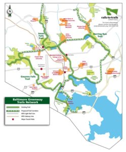
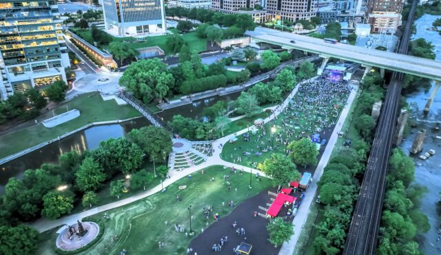
The Baltimore Greenway Trails Network is central to the creation of this new green infrastructure. Headed by the Baltimore Greenway Trails Coalition, the project seeks to create a world class, 35-mile network of urban trails that link together the diverse neighborhoods, cultural amenities and outdoor resources that make up the landscape of Baltimore City. A recent report by the Greater Washington Partnership (Economic and social benefits of completing the Baltimore Greenway, October 2020) found that each of the neighborhoods within a half mile of the Greenway are composed of 58% African American residents and have a home ownership rate of 48%, representing similar demographic diversity and home ownership rates to Baltimore as a whole. The report finds that a $28M investment to complete the trail will bring more than $150M in potential economic and social benefits to a wide cross section of Baltimore’s population.
Currently, Toole Design is working with support from the Rails to Trails Conservancy to close a critical gap on the Greenway Trails Network between the much-loved Inner Harbor Waterfront Promenade trail and the Norfolk Southern trail that will connect the southeast and northeast neighborhoods to Herring Run Park. We are designing a generous shared use path that will feel relaxing and enjoyable to the widest range of people using it. Most importantly, it will provide a safer and more comfortable non-motor vehicle mobility option for people to access amenities on either end, as well as broader transportation and employment opportunities.
Toole Design is also supporting the Greenway Trails Network with a project on the west side of the City to create another critical link between the Middle Branch Trail and Carroll Park’s gateway to the Gwynns Falls Trail. Here, we are designing a two-way protected bicycle lane on Bush Street where parked cars and additional buffer space help create a safer and more enjoyable riding experience while simultaneously opening a connection from the Inner Harbor to Leakin Park on the western edge of the city.
REIMAGINE MIDDLE BRANCH
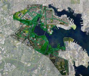
The Middle Branch is envisioned to be Baltimore’s next great recreational and natural waterfront, with water and land-based attractions along the Patapsco River shoreline connecting to a network of parks and paths. A transformed waterfront will generate opportunity for investment while creating a new front yard for local neighborhoods, particularly those that have been disconnected from their waterfront for generations. Connecting these neighborhoods with safe access to the waterfront will be key to the plan’s success. Toole Design is a subconsultant to James Corner Field Operations for the Middle Branch Master Plan, a multi-year public-private partnership formed to build a system of world class parks, trails, and public amenities along 11 miles of the Patapsco River’s Middle Branch shoreline from the Locust Point Marine Terminal to Masonville Cove.
The plan has a strong justice, equity, diversity, and inclusion (JEDI) focus that will drive the infrastructure, policy and programmatic recommendations and eventual design. The project has extensive stakeholder and community engagement to ensure residents see themselves in the plan and are highly involved in the development and implementation of the plan.
Toole Design’s work starts with an equity focus and includes the planning and design of greenway development for the Loop Trail system, neighborhood connectivity to the waterfront, analysis and design of intersections and roadway/trail interactions.
BAYBROOK CONNECTOR
The Baybrook Connector is integral to the transformation of the Middle Branch waterfront. Toole Design is leading a project with the Greater Baybrook Alliance that presents a unique opportunity to extend the popular Gwynns Falls Trail beyond its current endpoint to access the waterfront and nearby neighborhoods that have been disconnected for decades. As such, connectivity with the surrounding south Baltimore neighborhoods and safe access to a greater range of regional services and mobility options will be key to the plan’s success.
The coalition of public and private partners working to transform Baltimore understand more than ever how expansion of the greenways system can make it safer and more convenient to get around while benefiting the regional economy for everyone. Toole Design is honored to be part of this emerging story in Baltimore’s history.