Marblehead Rail Trail Planning and Design
Marblehead, MA
Project Summary
The Marblehead Rail Trail has served as a beloved community connector and recreational trail since rail operations ended along the corridor in the late 1950s. Today, the 4.5-mile coastal route weaves through the historic and natural heart of Marblehead, while also forming part of the larger East Coast Greenway.
Since 2020, Toole Design has collaborated with the Town of Marblehead, community members, and local stakeholders to create a long-term vision for improving safety, accessibility, and user experience along the corridor. That planning work has now advanced into design for the Salem and Swampscott branches of the trail. Read on to learn more about each phase of work.
Creating a Corridor-Wide Vision
The Marblehead Former Railroad Right-of-Way Trail Plan established a long-term vision for a safer, more accessible, and more comfortable trail while balancing the corridor’s many roles: a recreational path, a natural resource, a utility route, and a connection to schools, neighborhoods, and local destinations.
As part of the Plan, our team developed conceptual designs for the trail’s seven primary street crossings, recommendations for the trail cross-section, landscape improvements and amenities, and supporting policy and program initiatives. The street crossing improvements were particularly vital for advancing safety and accessibility because, in several locations, the trail crosses high-volume thoroughfares with high speeds.
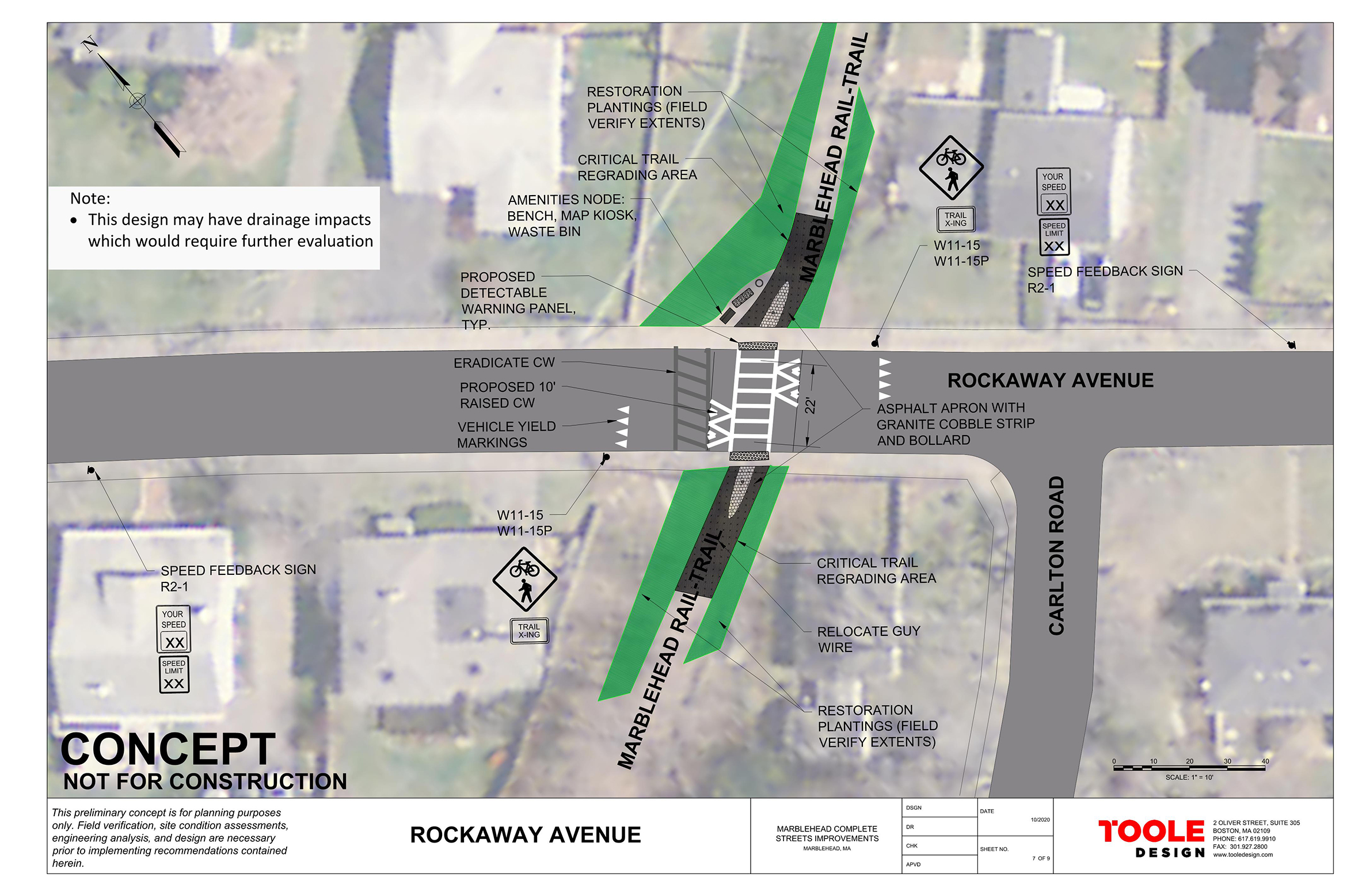

To help advance the Plan’s recommendations, we also collaborated with the Town of Marblehead on a grant application to the MassDOT Complete Streets Funding Program. In 2021, the Town was awarded nearly $400,000 in implementation funding for the Plan’s highest-priority street crossing improvements, which were identified through community input and crash history.
Advancing Design Across Three Trail Segments
Salem Branch: Lafayette Street to Lead Mills
Building on the corridor-wide vision, Toole Design led a team in 2022 to advance preliminary design for the first section of the Salem Branch nearest the Salem town line. The work focused on upgrading an existing shared-use path with stabilized surfacing that meets safety and accessibility guidelines.
This section of the Marblehead Rail Trail passes through a varied landscape of meadows, wooded areas, and both coastal and inland wetland resource areas. Since the 1960s, the former rail corridor has also served as a conduit for utility infrastructure. In 2018, the Board of Selectmen signed a memorandum of agreement with the Town of Marblehead Water and Sewer Commissioners and the Marblehead Municipal Light Department to establish a recreational easement. This agreement ensures that the right-of-way can continue to effectively and sustainably serve its purposes as both a utility corridor and a recreational trail.
Working within these constraints, we coordinated topographic survey, environmental mapping, geotechnical and hydraulic due diligence, permitting documentation, and the design for two footbridges by our subconsultants. Our project team designed the trail and landscaping through 75% construction documents. We also provided AASHTO-based guidance on trail access points, helping the Town evaluate how to make entries safer for trail users while still accommodating maintenance and utility needs.
Salem Branch: Lead Mills to West Shore Drive
Since 2024, Toole Design has continued design work along the Salem Branch, developing 75% design documents for the segment from Lead Mills to West Shore Drive (Section 3). A key focus of this phase is the West Shore Drive crossing, where the rail trail connects with the surrounding street network. Through our related work on the Town’s Complete Streets Prioritization Plan and Bicycle Facilities Plan, our team was able to connect the trail design to broader multimodal improvements in Marblehead.
Swampscott Branch: Smith Street to Swampscott Town Line
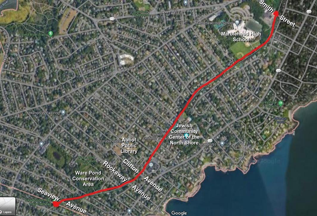
Concurrent with the Salem Branch, we are providing design and engineering services for the Swampscott Branch of the Marblehead Rail Trail. This section extends from Smith Street south to the Swampscott town line, where it connects to the Swampscott Rail Trail.
This corridor includes several important street, neighborhood, and community connections, including access to Marblehead High School, the post office, a Jewish community center, the public library, the Ware Pond Conservation Area, and the local street network. In some locations, the trail and roadway share space, requiring careful attention to comfort, visibility, and safety for all users. The design also balances trail access, maintenance and utility access, and strategies to prevent unauthorized vehicle entry.
becoming a Signature Trail Destination
Together, these planning, design, and engineering efforts are helping the Town of Marblehead move toward a more cohesive Marblehead Rail Trail. Across each phase, our team has embedded landscape architecture considerations, including planting recommendations, green infrastructure, wayfinding signage, and integration of historic remnants that celebrate the corridor’s railroad legacy. The work has also been guided by public input through stakeholder sessions, public meetings, and site walks with the Marblehead Historical Commission and community members.
With 90% design plans and environmental permitting for each section expected to be completed by the end of 2026, the Town is moving closer to implementing a more connected and accessible trail. As these improvements move forward, we’re excited to see the trail recognized through the 2026 MassTrails10 campaign, underscoring its growing role as a signature trail destination in Massachusetts.